Port Phillip
| Ocean type | Saline, Permanent, Natural |
| Primary sources | Yarra River, Patterson River, Werribee River, Little River, Kororoit Creek |
| Primary outflows | Bass Strait |
| Basin countries | Australia |
| Surface area | 1,930 km2 (750 sq mi) |
| Average depth | 8 m (26 ft) |
| Water volume | 25 km3 (6.0 cu mi) |
| Shore length1 | 264 km (164 mi) |
| Islands | Swan Island, Duck Island, Mud Islands |
| Settlements | Melbourne, Geelong, Frankston, Mornington, Queenscliff, Sorrento |
| 1 Shore length is not a well-defined measure. | |
- "Port Phillip" may also refer to a Local Government Area called the City of Port Phillip.
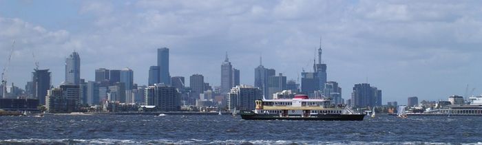
Port Phillip (also commonly referred to as Port Phillip Bay or (locally) just The Bay) is a large bay in southern Victoria, Australia; it is the location of Melbourne. Geographically, the bay covers 1,930 square kilometres (480,000 acres) and the shore stretches roughly 264 km (164 mi). Although it is extremely shallow for its size, most of the bay is navigable. The deepest portion is only 24 metres (79 ft), and half the region is shallower than 8 m (26 ft). The volume of the water in the bay is around 25 cubic kilometres (6.0 cu mi).
The area around Port Phillip was originally part of the Wathaurong (to the west), Wurundjeri (north) and Boonwurrung (south & east) nations territories prior to European settlement, while its waters and coast are home to species of life such as the Australian Fur Seal, whales, dolphins, corals and many species of bird including the waterbird, migratory waders, White-faced Storm-Petrel, Silver Gull, Australian Pelican, Pacific Gull, Australian Gannets and the critically endangered Orange-bellied Parrot.
The first Europeans to enter the bay were the crews of the Lady Nelson, commanded by [John Murray, Australian explorer|John Murray] and, ten weeks later, the HMS Investigator commanded by Matthew Flinders, in 1802. Subsequent expeditions into the bay took place in 1803 to establish the first settlement in Victoria, near Sorrento, but was abandoned in 1804. Thirty years later, settlers from Tasmania returned to establish Melbourne, now the state's capital city, at the mouth of the Yarra River in 1835 and Geelong in Corio Bay in 1838. Today Port Phillip is the most densely populated catchment in Australia with an estimated 3 million people living around the bay; Melbourne's suburbs extend around much of the northern and eastern shorelines, and the city of Geelong sprawls around Corio Bay, in the bay's western arm.
Contents |
Formation & early history
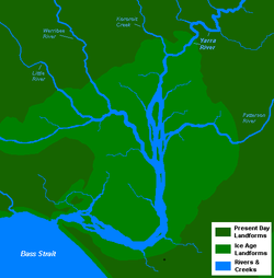
Port Phillip was formed 7,000 to 10,000 years ago at the end of the last Ice Age, when the sea-level rose to drown what was then the lower reaches of the Yarra River, vast river plains, wetlands and lakes. The Yarra and other tributaries flowed down what is now the middle of the bay, formed a lake in the southern reaches of the bay, dammed by The Heads, subsequently pouring out into Bass Strait.[1]
The Aboriginal people were in occupation of the area long before the bay was formed, having arrived at least 20,000 years ago and possibly 40,000 years ago. Large piles of semi-fossilised sea-shells known as middens, can still be seen in places around the shoreline, marking the spots where Aboriginal people held feasts. They made a good living from the abundant sea-life, which included penguins and seals. In the cold season they wore possum-skin cloaks and elaborate feathered head-dresses.
European exploration
The first Europeans to see Port Phillip were the crew of the Lady Nelson, commanded by John Murray, which entered the bay on 15 February 1802.[2] Murray named the bay Port King after the Governor of New South Wales, Philip Gidley King, but King later renamed it Port Phillip, in honour of his predecessor Arthur Phillip.[3]
About ten weeks after Murray, Matthew Flinders in the Investigator also found and entered the port,[2] unaware Murray had been there. The official history of Nicholas Baudin's explorations in Le Géographe claimed they too had sighted the entrance at that time (30 March 1802) but this is almost certainly a later embellishment or error, being absent from the ship's logs and Baudin's own accounts.[4] As a result of Murray's and Flinders' reports, King sent Lieutenant Charles Robbins in the Cumberland to explore Port Phillip fully. One of his party, Charles Grimes, became the first European to walk right round the bay, and thus to discover the mouth of the Yarra, on 2 February 1803.
British settlement
King decided to place a convict settlement at Port Phillip, mainly to stake a claim to southern Australia ahead of the French. In October 1803 a party led by Lt-Col David Collins and consisting of about 400 people landed near the modern site of Sorrento, where they established a settlement at Sullivan Bay which they called Hobart. Lack of fresh water and good timber, however, led this, the first attempt at European settlement in Victoria, to be abandoned in May 1804. Collins and party sailed to Tasmania, where they established the modern Hobart. Prior to abandonment one convict, William Buckley, escaped from the settlement in a stolen canoe. Buckley later took up residence in a cave near Point Lonsdale on the western side of the bay's entrance, The Rip.
Port Phillip was then left undisturbed until 1835, when settlers from Tasmania led by John Batman and John Pascoe Fawkner (who had been at the Sorrento settlement as a child) established Melbourne on the lower reaches of the Yarra. John Batman encountered William Buckley who then became an important participant in negotiations with the local indigenous tribesmen. In 1838 Geelong was founded, and became the main port serving the growing wool industry of the Western District. For a time Geelong rivalled Melbourne as the leading settlement on the bay, but the Gold Rush which began in 1851 gave Melbourne a decisive edge as the largest town in Victoria.
Modern use
As Melbourne prospered, its wealthy classes discovered the recreational uses of Port Phillip. Bayside suburbs such as St Kilda and Brighton were established on the east shore of the bay. Later, resorts further south such as Sorrento and Portsea became popular. The more swampy western shores of the bay were not so favoured, and have been used mainly for non-residential purposes such as the Point Cook Royal Australian Air Force base and the Werribee Sewage Farm. In recent decades the population along the western side of the bay has grown more rapidly.
In the 21st century, property along the Port Phillip coastline continues to be highly sought after. Port Phillip continues to be extensively used for recreational pursuits such as swimming, cycling, boating and fishing. The bay also features a number of historical walks and fauna reserves.[5] The traditional land owners of the area have also been acknowledged at a number of sites.
Geography


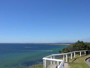
Port Phillip lies in southern Victoria, separated from Bass Strait by the Bellarine Peninsula to the southwest and Mornington Peninsula to the southeast. It is the largest bay in Victoria and one of the largest inland bays in Australia. The narrow entrance to the bay, called the Rip, between Point Lonsdale and Point Nepean, features strong tidal streams made turbulent by the uneven contours of the seabed. The best time for small craft to enter the Rip is at slack water. Large ships require expert local guidance to enter and exit, provided by the Port Phillip Sea Pilots. Work has commenced to deepen the channel entrance, to allow newer, larger container ships to access Melbourne's docks. This deepeninG has resulted in larger tides and beaches like Portsea having considerable erosion
The eastern side of the bay is characterised by sandy beaches extending from St Kilda, Sandringham, Beaumaris, Carrum, and down the Mornington Peninsula to Frankston, Safety Beach/Dromana and Rye to Portsea. Longshore drift carries sand from south to north during winter and from north to south during summer. Cliff erosion control has often resulted in sand starvation, necessitating offshore dredging to replenish the beach. On the western side of the bay there is a greater variety of beach types, seen at Queenscliff, St Leonards, Indented Head, Portarlington, and Eastern Beach.
Numerous sandbanks and shoals occur in the southern section of the bay, and parts of the South Channel require occasional maintenance dredging. Swan Bay, adjacent to Queenscliff is an important feeding ground for waterbirds and migratory waders. The Mud Islands, off Sorrento, are an important breeding habitat for White-faced Storm-Petrel, Silver Gull, Australian Pelican and Pacific Gull. Australian Gannets also breed on navigation beacons in this area, and it also hosts breeding colonies of Australian Fur Seal. Salt marshes in the northwestern sections of the bay, such as that in the Werribee Sewage Farm and the adjacent Spit Nature Conservation Reserve, are within the Port Phillip Bay (Western Shoreline) and Bellarine Peninsula Ramsar Site, listed as wetlands of international importance under the Ramsar Convention, and the critically-endangered Orange-bellied Parrot is found at three wintering sites with saltmarsh habitat around Port Phillip and the Bellarine Peninsula.
Beaches
Port Phillip hosts many beaches, most of which are flat, shallow and long, with very small breaks making swimming quite safe. This attracts many tourists, mostly families, to the beaches of Port Phillip during the summer months and school holidays. Water sports such as body boarding and surfing are difficult or impossible, except in extreme weather conditions. Most sandy beaches are located on the bay's northern, eastern and southern shorelines, while the western shorelines host a few sandy beaches, there mostly exists a greater variety of beaches, swampy wetlands and mangroves. The occasional pebble beach and rocky cliffs can also be found, mostly in the southern reaches.
- Major beaches include: St. Kilda Beach, Brighton Beach, Sandringham Beach, Dromana Beach
Rivers & creeks
- Rivers: Yarra River, Maribyrnong River, Patterson River, Little River, Werribee River.
- Creeks: Kananook Creek, Sweetwater Creek, Cowies Creek, Kororoit Creek, Chinamans Creek.
Islands
Due to its shallow depth, numerous artificial islands and forts have been built, however, despite the depth, it only hosts a few true islands. Many sandy, muddy banks and shallows exist in its southern reaches, such as Mud Islands, but most islands are located in the marshy shallows of Swan Bay. Some of the bay's major islands include:
- Swan Island
- Mud Islands
- Duck Island
- South Channel Fort (artificial)
- Pope's Eye (artificial)
Surrounding mountains & hills
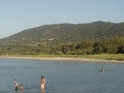

- Arthurs Seat 314m
- Mount Martha 160m
- Mount Eliza
- Olivers Hill
Surrounding lakes
- Albert Park Lake
- Patterson Lakes (artificial)
- Lake Victoria
- Salt Lagoon
- Lake Connewarre
- Lake Borrie
- RAAF Lake
- Sanctuary Lakes (artificial)
- Cherry Lake
Ferries
Peninsula Searoad Transport operates a vehicular ferry service across the mouth of the bay between Queenscliff and Sorrento using two roll-on roll-off vessels. Ferries also run from St Kilda to Williamstown, Victoria across Hobsons Bay. These ferries, like the many recreational cruises, mostly operate for tourists and run around the bay in various locations.
- Spirit of Tasmania Ferry (Passenger & Vehicles)
- Between: Station Pier, Port Melbourne
- And: Devonport, Tasmania
- Searoad Ferries (Passenger & Vehicles)
- Between: Sorrento Pier, Sorrento
- And: The Cut Pier, Queenscliff
Shipping
History
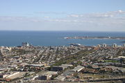
The southern section of the Bay near the Heads is covered by extensive sand banks, known as the "Great Sand". A shipping channel was dredged in an east-west direction from the Heads to near Arthur's Seat late in the nineteenth century, and maintained ever since. Early shipping used piers at Sandridge (Port Melbourne), but later moved to various wharves along the Yarra River, which make up today's Port of Melbourne.[6] The Melbourne Harbor Trust and Geelong Harbor Trust were responsible for the piers and wharves in their respective cities - they are now the governemtn owned Port of Melbourne Corporation and the privately operated GeelongPort.
Today, the Port of Melbourne has grown to become Australia's busiest commercial port, serving Australia's second largest city and handling an enormous amount of imports and exports into and out of the country. The Port of Geelong also handles a large volume of dry bulk and oil, while nearby Port of Hastings on Western Port handles steel and oil products.
In 2004 the Victorian Government launched the Port Phillip Channel Deepening Project to deepen the existing shipping channels and the lower Yarra to accommodate deeper draft vessels. The lower Yarra sediments were identified as likely to be contaminated with toxic chemicals and heavy metals, and were to be contained within a sealed berm clear of the shipping channels south of the Yarra entrance. The vessel chosen for the dredging is the Queen of the Netherlands. 52 environmental groups, recreational fishing groups, and divers' groups formed the "Blue Wedges" group to oppose the proposed channel deepening and dredging with organised protests carried out, culminating in the group taking action in the Federal Court in January 2008 against the Commonwealth to stop it signing off on the project.[7] On 15 January 2008 it was announced that their appeal was dismissed,[8] with dredging starting soon after. The government announced the completion of works in November 2009, ahead of schedule and $200 million under budget.[9]
Shipping channels

- South Channel - Extends from the area of the rip in an easterly direction where it terminates off the coast of Arthurs Seat. Vessels with a draught of 11.6m can be navigated through the channel at all tides. This is the main commercial shipping channel in the south of the bay allowing large ships access between the entrance of the bay and its middle regions.
- West Channel - Extends from the area of the rip, heads towards the north-west and ends off the coast of St Leonards. The depth varies, in May 1998 there was a minimum of 4.1 metres. Non-commercial vessels are still navigated through the channel, however it is no longer used for commercial shipping.
- The Rip - Also referred to as "the heads" for shipping purposes, vessels with a draught of 11.6m can be navigated through the Heads during any tide.
- Melbourne Channels - Extends northwards through Hobsons Bay towards Station Pier and the entrance to the Yarra River. It is dredged to a depth of 13.1 metres and is the main shipping channel through the north of the bay into Melbourne's ports and docks. The channels include:
- Melbourne Channel
- Williamstown Channel
- Port Melbourne Channel
- Geelong Channels - Begins off the coast of Point Richards and runs in a westerly direction through Outer Harbour and into Corio Bay where it splits in two heading north towards the modern Port of Geelong and south towards Cunningham Pier. The City Channel while once used for wool exports is no longer used for commercial shipping. The channels include:
- Point Richards Shipping Channel
- Wilson Spit Shipping Channel
- Hopetoun Shipping Channel
- City Channel
- Corio Channel
Shipping & cargo docks
- Station Pier
- Princess Pier
- Webb Dock
- Gellibrand Pier
- Point Wilson Pier
- Refinery Pier
- Lascelles Wharf
- Corio Quay
- Bulk Grain Pier
- Cunningham Pier
- Point Henry Pier
Ecology

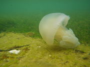
Jellyfish are a familiar sight in Port Phillip, and its waters are home to species such as Australian Fur Seals, Bottlenose dolphins,[10] Common dolphins,[10] and Humpback whales.[10] The smooth toadfish is one of the most common fishes in muddy areas.[11] The bay has many endemic species including the blue angelfish and fantastic sponge walls on the Lonsdale wall in the heads of the Bay.
A variety of seabirds, such as Australasian Gannets,[12] White-faced Storm-Petrels, Silver Gulls, Pacific Gulls, and Australian Pelicans, feed on fish living in the bay.
Environmental issues
Like the Yarra which flows into it, Port Phillip also faces the environmental concerns of pollution and water quality.
In 2008, the owner and master of Hong Kong-registered container vessel MV Sky Lucky were found liable for illegally disposing garbage into Port Phillip Bay. convicted and fined $35,000.[13]
Other features

Lighthouses
- Williamstown Lighthouse (1840, 1849, 1934) - Williamstown
- Queenscliff High Light (1843, 1862) - Queenscliff
- Queenscliff Low Light (1863) - Queenscliff
- Eastern Lighthouse (1854, 1883) - McCrae
- South Channel Pile Light (1874) - Port Phillip
- Point Lonsdale Lighthouse (1902) - Point Lonsdale
- Port Melbourne Lighthouses (1924) - Port Melbourne
Major marinas & piers
- Station Pier
- St Kilda Pier
- St Kilda Marina
- Sandringham Marina
- Mornington Pier
- Martha Cove Marina
- Dromana Pier
- Rosebud Pier
- Rye Jetty
- Blairgowrie Marina
- Sorrento Pier
- Portsea Pier
- Point Lonsdale Jetty
- Queenscliff Harbour
- Portarlington Pier
- Bellarine Street Jetty
- Cunningham Pier
- Werribee South Jetties
- RAAF Williams Pier
- Altona Pier
Life saving clubs
- Altona LSC
- Aspendale LSC
- Bancoora SLSC
- Barwon Heads/13th Beach SLSC
- Beaumaris LSC
- Black Rock LSC
- Bonbeach LSC
- Brighton LSC
- Carrum SLSC
- Chelsea Longbeach LSC
- Dromana Bay LSC
- Edithvale LSC
- Elwood LSC
- Frankston LSC
- Gunnamatta SLSC
- Half Moon Bay SLSC
- Hampton LSC
- Mentone LSC
- Mordialloc LSC
- Mornington LSC
- Mount Martha LSC
- Point Lonsdale SLSC
- Point Leo SLSC
- Port Melbourne LSC
- Portsea SLSC
- Rosebud & McCrae LSC
- Sandridge LSC
- Sandringham LSC
- Seaford LSC
- Sorrento SLSC
- South Melbourne LSC
- St Kilda LSC
- Williamstown LSC
Yacht clubs

- Altona Yacht Club
- Beaumaris Yacht Club
- Black Rock Yacht Club
- Blairgowrie Yacht Squadron
- Carrum Sailing Club
- Chelsea Yacht Club
- Docklands Yacht Club
- Elwood Sailing Club
- Frankston Yacht Club
- Hampton Sailing Club
- Hobsons Bay Yacht Club
- Indented Head Yacht Club
- McCrae Yacht Club
- Mordicalloc Yacht Club
- Mornington Yacht Club
- Ocean Racing Club of Victoria
- Port Melbourne Yacht Club
- Queenscliff Cruising Yacht Club
- Rosebud Yacht Club
- Royal Brighton Yacht Club
- Royal Geelong Yacht Club
- Royal Melbourne Yacht Squadron
- Royal Yacht Club of Victoria
- Sandringham Yacht Club
- Sorrento Sailing Couta Boat Club
- Williamstown Sailing Club
Shipwrecks
Some of the more significant and historical shipwrecks in the bay include;
- Mountain Maid - sunk off Swan Island after a collision with the SS Queen (1856)
- Wauchope - sunk off the coast of Sorrento (1918)
- Ozone - scuttled off Indented Head (1925)
- HMVS Cerberus - scuttled in Half Moon Bay, Black Rock (1926)
- HMAS J3 - scuttled in Swan Bay (1926)
- HMAS J7 - scuttled off Hampton Beach (1926)
ELISA Ramsden
Tourism
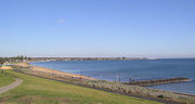
The bay is one of Victoria's most popular tourist destinations. Many residents of Melbourne holiday on the shorelines of the bay, particularly the eastern and southern shorelines, most annually, either camping in tents, caravan or villas in caravan parks, sharing rental houses or staying in holiday homes.
Recreation and sport
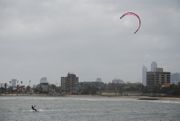
Port Phillip's mostly flat topography and moderate waves make perfect conditions for recreational swimming, kitesurfing, windsurfing, sailing, boating, scuba diving and other sports.
Port Phillip is home to 36 Yacht clubs. It also hosts the Melbourne to Hobart and Melbourne to Launceston Yacht Races. Port Phillip is also home to a number of marinas, including large marinas at St Kilda, Geelong and Brighton. For the 1956 Summer Olympics, it hosted the sailing events.
Dozens of lifesaving clubs dot Port Phillip, especially on the east coast from Altona to Frankston. These clubs provide volunteer lifesaving services and conduct sporting carnivals.
Port Phillip is also known as a temperate water scuba diving destination. The shore dives from beaches and piers around the Bay provide a wide variety of experiences on day and night dives. Boat diving in Port Phillip provides access to a remarkable variety of diving environments including wrecks, reefs, drift dives, scallop dives, seal dives and wall dives. Of particular interest are the five scuttled J-Class World War 1 submarines and the Ships' Graveyard off Torquay.
The are also a number of bike paths, including the Bayside Trail and the Hobsons Bay Coastal Trail.
See also
- History of Port Phillip and Victoria
- Geography of Port Phillip
- Beaches in Port Phillip
- Port Phillip Channel Deepening Project
- Fort Queenscliff
- Fort Nepean
- Fort Pearce
- South Channel Fort
References
- ↑ http://www.informaworld.com/smpp/content~content=a725292003~db=all
- ↑ 2.0 2.1 Norman Houghton - 'The Story of Geelong' link
- ↑ Port Phillip Conservation Counci: Excerpts from the 'Port Phillip Survey 1957-1963'
- ↑ Ernest Scott. Terre Napoleon: A history of French explorations and projects in Australia at Project Gutenberg
- ↑ Parks Victoria. "Port Phillip". http://www.parkweb.vic.gov.au/1park_display.cfm?park=58. Retrieved 2009-12-20.
- ↑ "History of the port". www.portofmelbourne.com. http://www.portofmelbourne.com/community/maritimeheritage/porthistory.asp. Retrieved 2009-11-08.
- ↑ The Age Newspaper,Court threat to channel deepening
- ↑ The Age Newspaper,Bay dredge gets go-ahead
- ↑ Jason Dowling (November 26, 2009). "Labor hails dredging success, says bay is clean". The Age. theage.com.au. http://www.theage.com.au/national/labor-hails-dredging-success-says-bay-is-clean-20091125-jrtz.html. Retrieved 2009-11-27.
- ↑ 10.0 10.1 10.2 Jason Gedamke, "Australia. Progress report on cetacean research, January 2006 to December 2006, with statistical data for the calendar year 2006."
- ↑ Melbourne's Wildlife (Museum Victoria, 2006), 324.
- ↑ T.M. Pyk, A. Bunce, and F.I. Norman, "The influence of age on reproductive success and diet in Australasian gannets (Morus serrator) breeding at Pope's Eye, Port Phillip Bay, Victoria," Australian Journal of Zoology, Vol. 55 No. 5, 2007, pp. 267–274.
- ↑ http://epanote2.epa.vic.gov.au/EPA/publications.nsf/2f1c2625731746aa4a256ce90001cbb5/58f1a95bb5f860a4ca2574fc007c64bb/$FILE/1253.pdf
External links
- Large-scale map of Port Phillip showing beaches and recreational facilities
- Port Phillip Sea Pilots
- Shipwreck Info at Heritage Victoria
|
||||||||